SKIM products
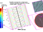
The SKIM radar (SKAR) will operate at Ka band (around 35.75 GHz) with a B=200 MHz bandwith, and a high pulse repetition frequency (up to 32 kHz). SKAR will measure both the amplitude and phase of radar echoes. The radar power P is proportional to the amplitude squared and is related to the slopes of the sea surface, with some perturbation by clouds and rain. while the phase shift is related to the relative velocities of the radar and the detected targets. Targets will be separated thanks to the narrow antenna beam, which makes a footprint of 6 km diameter on the Earth surface.
Each footprint is illuminated by a series of (typically 1000) pulses that make up a cycle. For each radar pulse, the echoes arriving from different distances are separated thanks to radar bandwidth, with a resolution in the line of sight that is c/2B = 0.75 m, projecting to a ground range resolution of 3.75 m at 12° incidence.
In addition to the "standard altimeter" processing of the nadir beam (similar to Sentinels 3 and 6), two processing chains will be operated in parallel,
- A pulse-pair estimation of the velocity providing a "Line of sight" velocity ULOS for each "range gate" r , that can be combined with the radar power P(r) at each range r.
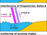
- A delta-K processing that provides velocities for the entire footprint, corresponding to the velocity of patters of different wavelenghts (typically 8, 12 and 16 m).
The pulse-pair chain is illustrated in this schematic, going from the basic measurement (Level 0) of power and velocity, through the calculation of spectra and co-spectra of power and velocity (for wave measurements), the estimation of a geophysical velocity UGD and the estimation of a radial current UR (Level 2a) after removal of the wave bias UWB.
This collection of radial velocities can be assimilated into ocean circulation models or combined to make a map of near-surface drift velocity vector (top 2 meters) U=(U,V) , and surface Stokes drift US=(US,VS). This mapped data, in the geometry of the ~ 300 km swath is the Level 2b product.
The accumulation of different passes (in less than one day for latitudes over 75°, and the mission cycle / subcycle ~ 10 days at the equator), gives a global gridded map of the quasi-Eulerian currents UE=(UE,VE). This is the Level 3 product.
In addition to the range resolution, a variable azimuthal resolution provided by unfocused SAR processing will allow the estimation of maps of velocity within each footprint, with typically 300 m resolution when looking broadside (90° away from the satellite track). This additional resolution will be used to remove outliers in cases where the ocean is not uniform within the footprint when estimating currents and wave spectra. It can also be used to measure velocity gradients at resolutions finer than the footprint.
Finally, the delta-K processing chain will provide 3 additional and independent values of radial currents at Level 2b: UR,8m , UR,12m , UR,16m from which the vertical shear over the top few meters of the ocean may be estimated.
All these products are described in more details in the separate pages...


